Yili (Ili) Travel Guide: Xinjiang's Most Enchanting Valley
Overview
Nestled in the heart of the Tianshan Mountains in northwestern Xinjiang, Yili (伊犁, Yīlí) stands as one of China's most spectacular and culturally rich travel destinations. This verdant valley, fed by the melting snow of the Tianshan range and blessed with abundant rainfall, transforms into a rolling tapestry of emerald meadows, wildflower-carpeted prairies, and crystal-clear alpine lakes throughout the year. Known as the "Land of the Golden Horse" in ancient times, Yili has captivated travelers, poets, and adventurers for centuries with its breathtaking natural beauty and deep cultural heritage.
The Yili Kazakh Autonomous Prefecture encompasses a vast territory of approximately 110,000 square kilometers, home to over 2.5 million people representing more than 40 ethnic groups. The Kazakhs, who constitute the majority of the population in the pastoral areas, have maintained their nomadic traditions for generations, creating a rich tapestry of customs, cuisine, and cultural practices that continue to thrive in the 21st century. This unique blend of natural splendor and human heritage makes Yili an unparalleled destination for travelers seeking authentic experiences far from the beaten path.
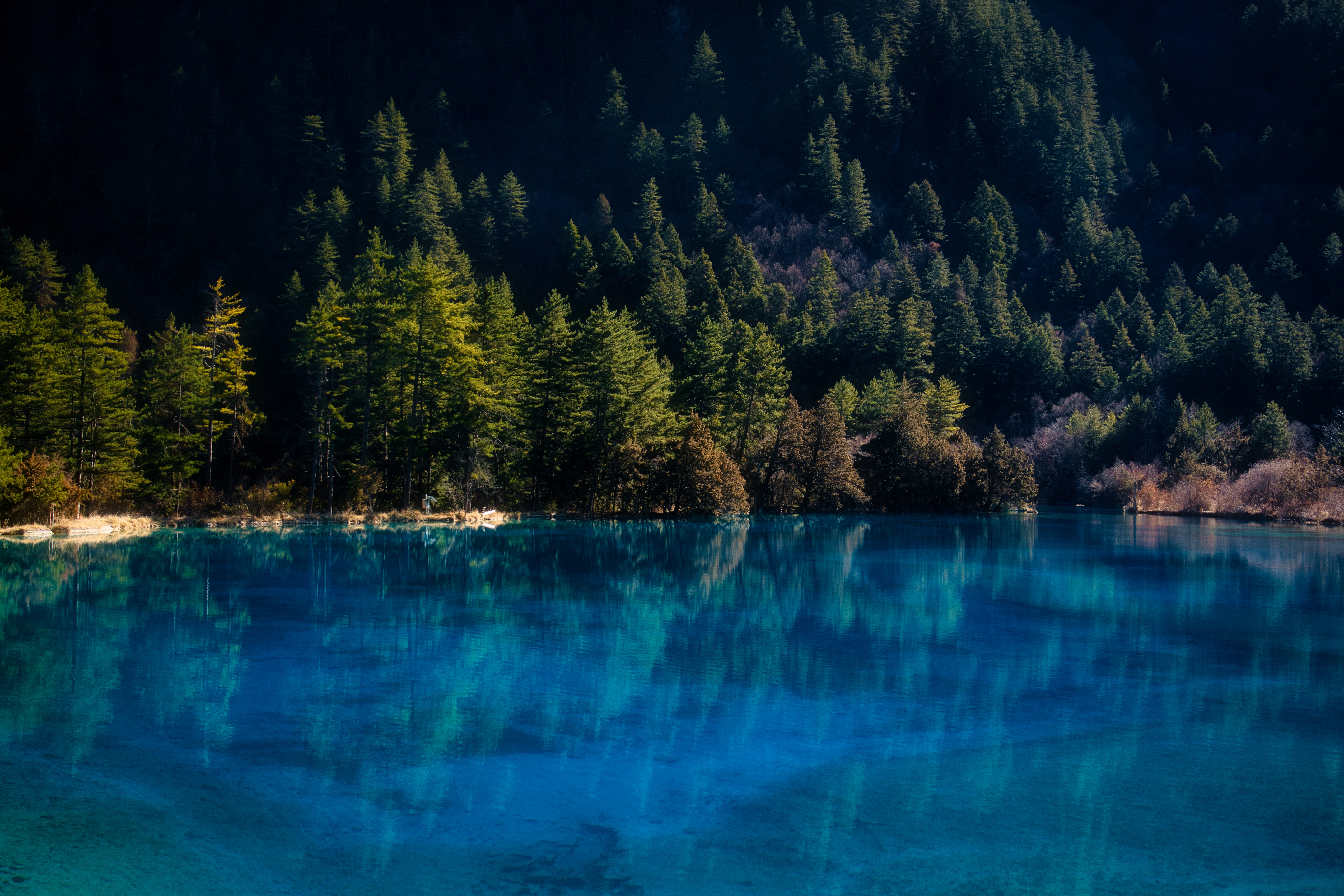
The region's geography is nothing short of extraordinary. The Tianshan Mountains create a natural barrier that captures moisture-laden winds from the Atlantic and Arctic oceans, resulting in Yili receiving more precipitation than any other part of Xinjiang. This climatic gift transforms the valley into a lush oasis, earning it the nickname "Xinjiang's Jiangnan" (the "land of fish and rice" south of the Yangtze). The Ili River, originating from the confluence of numerous glacial streams in the Tianshan, flows westward through the valley before continuing into Kazakhstan, forming the backbone of the region's irrigation system and ecological framework.
What truly sets Yili apart is its accessibility to some of Xinjiang's most iconic landscapes. The legendary Duku Highway (独库公路), one of China's most scenic driving routes, begins in Yili, offering travelers an unprecedented opportunity to traverse the heart of the Tianshan range. The Guozigou Bridge, a modern engineering marvel suspended high above a dramatic canyon, provides access to the eastern reaches of the region. Meanwhile, the world-renowned lavender fields of Yili bloom in spectacular purple waves, while the UNESCO-listed Kalajun Prairie and the famous Nalati Grassland offer quintessential alpine meadow experiences that rival the best pastures in Switzerland, Scotland, or Mongolia.
This comprehensive travel guide will take you through every aspect of planning and experiencing a journey to Yili, from understanding the best times to visit and navigating the region's transportation network to immersing yourself in Kazakh culture and discovering hidden gems that most travelers miss. Whether you're a nature lover seeking pristine landscapes, a culture enthusiast eager to experience traditional nomadic life, or an adventure traveler ready to tackle one of China's most spectacular roads, Yili promises an experience that will remain etched in your memory forever.
Geography and Natural Environment
The Yili Valley: A Natural Sanctuary
The Yili Valley (伊犁河谷, Yīlí Hégǔ) stretches for approximately 360 kilometers from east to west and varies in width from 20 to 120 kilometers. Flanked by the main Tianshan range to the north and the smaller Tianshan mountains to the south, this elongated basin sits at elevations ranging from 530 to 3,000 meters above sea level. The valley's unique orientation—running east-west rather than the typical north-south orientation of most valleys in the region—allows moisture-bearing winds to penetrate deeply, creating the exceptional agricultural and pastoral conditions that have supported human settlement here for millennia.
The Ili River (伊犁河, Yīlí Hé), the region's primary watercourse, originates from the confluence of the Küxü River, the Keshi River, and the Halede River in the western Tianshan. Flowing westward at an average rate of 180 cubic meters per second, it eventually crosses into Kazakhstan, where it joins the Syr Darya to form one of Central Asia's major river systems. The river's floodplain supports extensive wetlands, forests, and agricultural lands, providing crucial habitat for numerous species of birds, fish, and mammals.
The surrounding mountains play a critical role in shaping Yili's environment. To the north, the main Tianshan range rises dramatically, with peaks exceeding 5,000 meters including the formidable Khan Tengri (汗腾格里峰, 6,995 meters) and the magnificent Peerless Peak (雪莲峰, 6,627 meters). These permanent snowfields and glaciers feed the valley's rivers and streams, ensuring a reliable water supply throughout the year. The southern mountains, while lower, still reach elevations of 3,000-4,000 meters and create a rainshadow effect that helps maintain the valley's relatively mild and humid climate.
Climate Characteristics
Yili enjoys a temperate continental climate with distinct seasons and remarkable variety across different elevations. The valley floor experiences hot summers with average temperatures ranging from 20°C to 25°C (68°F to 77°F), while winters can be cold but generally less severe than in other parts of Xinjiang, with average temperatures hovering around -8°C to -15°C (18°F to 5°F). The mountainous areas, naturally, experience much more extreme conditions, with permanent frost at higher elevations and only two to three months of temperatures above freezing.
Precipitation is the key factor that makes Yili unique within Xinjiang. Annual rainfall ranges from 250-500 millimeters in the valley lowlands to over 800 millimeters in the high mountain zones—amounts that would be considered normal in eastern China but seem miraculous in the typically arid Tarim Basin. This moisture, combined with the fertile soils deposited by ancient lake beds and river systems, has created the conditions for the lush grasslands, dense forests, and productive agricultural lands that define the Yili landscape.
The best weather for travel generally occurs from May through October, when temperatures are comfortable and the landscape is at its most vibrant. July and August offer the warmest conditions and the most developed flower displays, though they also bring the highest tourist volumes. Spring (April-May) brings wildflower blooms and green pastures emerging from winter dormancy, while autumn (September-October) offers golden larch forests, clear skies, and the opportunity to witness the spectacular Kazakh tradition of livestock migration to winter pastures.
Top Attractions
Yili offers an extraordinary concentration of natural wonders and cultural sites. The following table summarizes the region's top attractions with essential information for planning your visit.
| Attraction | Chinese Name | Description | Admission (CNY) | Best Time |
|---|---|---|---|---|
| Nalati Grassland | 那拉提草原 | Famous alpine meadow with Kazakh culture, horse riding, and stunning mountain views | 135 (peak), 95 (off-peak) | June-September |
| Kalajun Prairie | 喀拉峻草原 | UNESCO World Heritage site, vast rolling grassland with seasonal flower displays | 140 (peak), 80 (off-peak) | June-August |
| Lavender Fields | 薰衣草庄园 | Expansive purple lavender plantations, perfect for photography | Free-50 depending on location | Mid-June to mid-July |
| Guozigou Bridge | 果子沟大桥 | Iconic cable-stayed bridge with spectacular canyon views | Free (viewing area) | Year-round |
| Duku Highway | 独库公路 | Legendary scenic road crossing the Tianshan Mountains | Road usage: free; scenic spots along route | June-October (limited season) |
Nalati Grassland (那拉提草原)
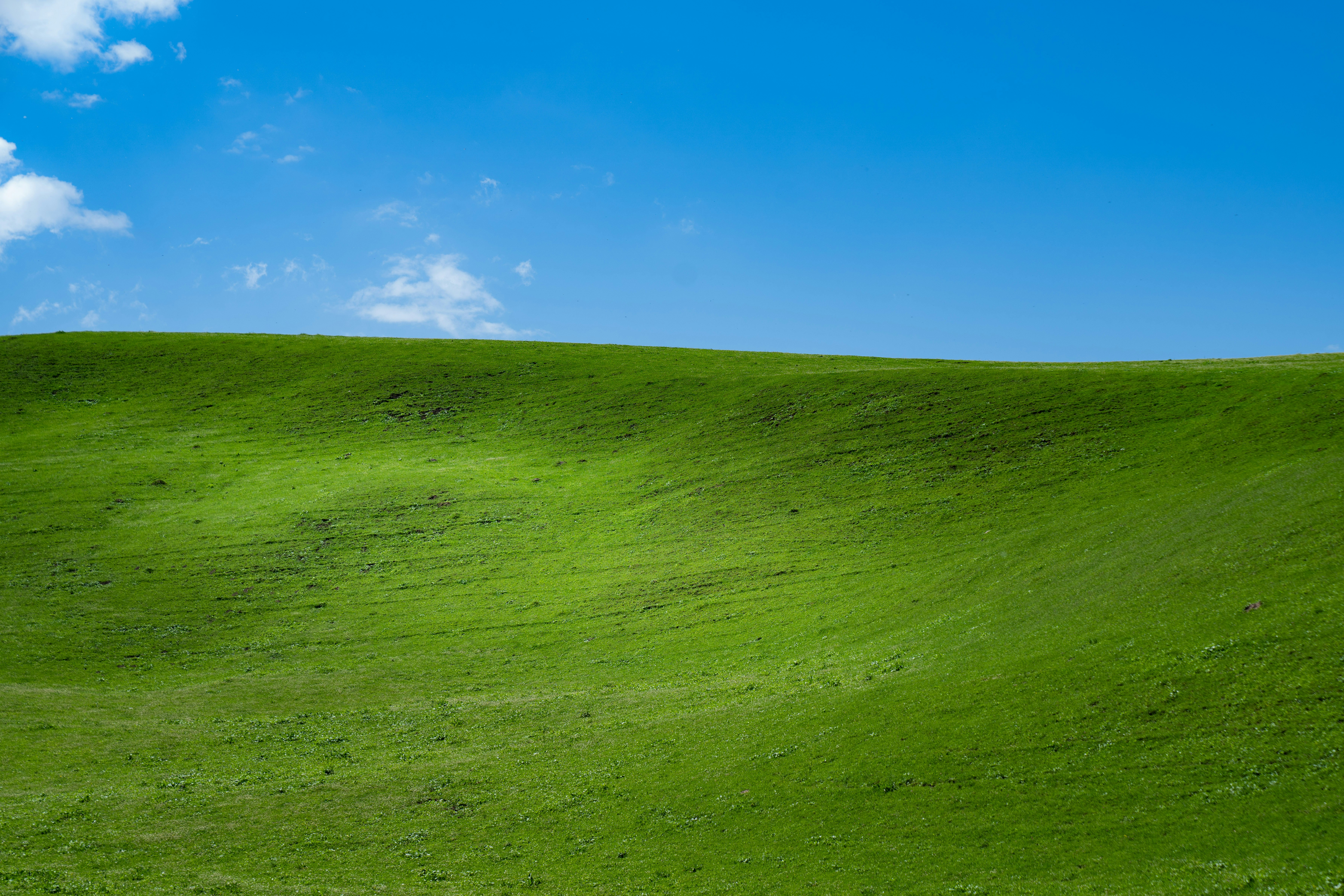
The Nalati Grassland (那拉提草原, Nàlātí Cǎoyuán) stands as one of the most celebrated alpine meadows in China and serves as the crown jewel of Yili's pastoral landscapes. Located in the southern foothills of the main Tianshan range, approximately 180 kilometers from Yining City, this 960-square-kilometer grassland sits at elevations between 1,800 and 2,800 meters, creating the perfect conditions for the lush vegetation that has made it famous.
The name "Nalati" originates from the Mongolian phrase meaning "the place where the sun first shines," a reference to the legend that this was the first valley in the region to receive the sun's rays each morning. This poetic etymology captures the essence of what makes Nalati so special—the way morning light cascades across the rolling hills, painting the landscape in ever-changing shades of gold, green, and purple as the day progresses.
The grassland divides into several distinct zones, each offering unique perspectives on the landscape. The main scenic area encompasses the central pasture, where you can witness traditional Kazakh nomadic life in action. Families still live in their distinctive white felt yurts (蒙古包, ménggǔbāo), tending to herds of sheep, horses, and cattle that graze freely on the verdant slopes. The sight of Kazakh herders on horseback moving across the meadow, their colorful traditional dress contrasting against the green grass and blue sky, creates an archetypal image of pastoral Central Asia.
The vegetation of Nalati displays remarkable diversity, reflecting the multiple ecological zones present within the area. At lower elevations, you'll find dense forests of spruce and fir interspersed with meadows of wildflowers. As you ascend, the forest gives way to alpine grasslands carpeted with a stunning variety of flora—purple salvia, yellow potentilla, white edelweiss, and countless others create a natural garden that reaches its peak of color in July and August. The famous "Nalati Flower Sea" has become one of the most photographed scenes in Xinjiang, with the rolling hills appearing to ripple with color as the wind moves through the blooms.
Activities at Nalati are plentiful and cater to various interests. Horse riding (骑马, qí mǎ) is the quintessential experience, with local Kazakh guides offering rides across the meadow and into the surrounding forests. The horses here are well-trained and accustomed to tourists, making this an excellent option for riders of all experience levels. For those who prefer not to ride, walking trails wind through the most scenic areas, with wooden boardwalks protecting the delicate meadow ecosystem while allowing visitors to access viewpoints and photo opportunities.
The grassland also offers opportunities to experience Kazakh culture directly. Many families operate homestays in their yurts, allowing visitors to spend the night in traditional accommodations, enjoy home-cooked Kazakh meals, and participate in daily activities like milk tea making, bread baking, and animal care. These immersive experiences provide insights into a way of life that has remained largely unchanged for centuries, offering a profound contrast to the rapidly modernizing cities of coastal China.
Practical Information:
- Location: Nalati Town, Xinyuan County, Yili Kazakh Autonomous Prefecture
- Hours: 8:00 AM - 8:00 PM (summer), 9:00 AM - 6:00 PM (winter)
- Transportation: Regular buses from Yining (approximately 3 hours, 35 CNY); self-drive via G218 highway
- Admission: 135 CNY during peak season (June-September), 95 CNY off-peak; additional fees for scenic bus (70 CNY) and horse riding (160 CNY for 2 hours)
- Accommodation: Yurt camps (200-400 CNY per night), Nalati town hotels (300-800 CNY)
Kalajun Prairie (喀拉峻草原)
The Kalajun Prairie (喀拉峻草原, Kālājùn Cǎoyuán) represents one of China's most outstanding examples of sub-alpine grassland ecosystem and was deservedly recognized as a UNESCO World Heritage Site in 2013 as part of the "Mountains of the Tianshan" transnational nomination. This 2,800-square-kilometer expanse of rolling hills, deep valleys, and alpine meadows offers a landscape experience distinct from the more developed Nalati, providing a sense of wilderness and pristine nature that appeals to travelers seeking solitude and authenticity.
The name "Kalajun" derives from the Kazakh words for "black" (kara) and "wide" (jün), perhaps referring to the vast dark-green appearance of the grassland when viewed from a distance or the mysterious quality of the deep valleys that dissect the landscape. The prairie sits at elevations between 1,300 and 3,950 meters, creating remarkable variety within a relatively compact area and allowing visitors to experience multiple ecological zones in a single day.
What makes Kalajun particularly distinctive is its dramatic topography. Unlike the more uniform slopes of typical alpine meadows, Kalajun features an almost sculptural quality—long, gentle ridges alternate with steep-sided gullies and valleys, creating a landscape that resembles a frozen sea of waves. The grass itself grows in distinctive patterns, with different species creating natural stripes and patches of varying colors that accentuate the contours of the terrain. From certain vantage points, particularly the famous "Five Colors Prairie" (五色花海, wǔsè huāhǎi) viewpoint, the prairie appears to shift between green, yellow, red, white, and purple as the light changes throughout the day.
The floral display at Kalajun is nothing short of extraordinary. The prairie supports over 200 species of flowering plants, creating a botanical spectacle that progresses through the summer months. In late May and early June, yellow buttercups and potentillas dominate the lower slopes, while purple salvia and blue lupine carpet the middle elevations. By July and August, the higher meadows explode with color as edelweiss, gentians, and alpine asters reach their peak. The famous "Lavender Sea" (薰衣草海, xūnyī cǎo hǎi) area within the park features particularly dense concentrations of purple flowers that create an almost surreal purple haze across the hillsides.
The western section of Kalajun centers on the Kaitike River Valley (阔克苏大峡谷, Kuòkèsū Dàxiá Gǔ), a spectacular canyon system with vertical cliffs, cascading waterfalls, and the famous "Human Body Grassland" (人体草原, réntǐ cǎoyuán)—a series of rolling hills shaped so precisely that they resemble the curves of a reclining human figure. This natural artwork has become one of the most iconic images of Yili, appearing in countless photography collections and travel publications.
The eastern section, known as the Jengish Chokusu area, features higher elevations and more dramatic mountain scenery, including views of the glacier-capped peaks that form the border with Kyrgyzstan. The Chogor (琼库什台, Qióngkùshìtái) village in this area offers access to some of the most pristine and least developed sections of the prairie, with traditional Kazakh villages and unchanged pastoral practices providing authentic cultural experiences.
Practical Information:
- Location: Tekes County, Yili Kazakh Autonomous Prefecture
- Hours: 8:00 AM - 7:00 PM (summer)
- Transportation: Approximately 4 hours from Yining by bus or self-drive; regular buses from Tekes County
- Admission: 140 CNY peak season (June-September), 80 CNY off-peak; scenic bus 90 CNY; cable car to western scenic area 120 CNY
- Accommodation: Yurt camps (250-500 CNY), Tekes County hotels (200-500 CNY)
Lavender Fields (薰衣草庄园)
The lavender fields of Yili represent one of the most surprising and spectacular agricultural landscapes in China. While Provence in France and Hokkaido in Japan are world-renowned for their lavender production, few travelers expect to find comparable purple seas in the heart of Central Asia. Yet Yili's climate—cool summers, abundant sunshine, and well-drained soils—proves ideally suited to lavender cultivation, and the region now produces over 90% of China's lavender oil, making it the country's undisputed lavender capital.
The history of lavender in Yili dates to the 1960s, when the Chinese government established experimental plantations as part of efforts to develop the region's agricultural economy. The success of these early trials led to gradual expansion, and today the lavender fields stretch across thousands of hectares in the Yining area, particularly around the towns of Xinyuan (新源) and Zhaosu (昭苏). The industry has developed sophisticated processing capabilities, with numerous distilleries producing lavender essential oil, dried flowers, and related products that are exported throughout China and beyond.
The visual impact of the lavender bloom is difficult to overstate. From late June through mid-July, the fields transform into vast purple carpets that seem to extend forever, their fragrance filling the air with a sweet, herbaceous perfume that permeates everything nearby. The sight of rows upon rows of lavender plants, their purple flower spikes swaying gently in the breeze, against the backdrop of the Tianshan Mountains creates scenes of almost otherworldly beauty. Photographers particularly favor the early morning and late afternoon hours, when the low angle of the sun adds depth and warmth to the purple hues.
Several designated lavender viewing areas have been developed to accommodate visitors. The most famous is the Yining Lavender Base (伊犁薰衣草基地), located approximately 30 kilometers from Yining City along the road toward Zhaosu. This area features extensive fields, viewing platforms, and processing facilities where you can observe the distillation process and purchase lavender products. Additional sites around Zhaosu and Tekes offer more intimate experiences with smaller-scale operations and fewer crowds.
Beyond photography, visitors can engage with the lavender industry in various ways. Many farms offer hands-on experiences where you can harvest lavender bundles, create your own sachets or dried arrangements, and learn about the cultivation and distillation processes. The Lavender Festival (薰衣草节, xūnyī cǎo jié), usually held in late June, celebrates the harvest with cultural performances, product exhibitions, and various activities that showcase the significance of lavender to the regional economy and identity.
Practical Information:
- Location: Various sites around Yining and Zhaosu; main viewing area 30km from Yining
- Peak Bloom: Mid-June to mid-July (varies slightly by year and elevation)
- Admission: Most fields free to visit; some designated areas charge 20-50 CNY
- Best Viewing Times: Early morning (6:00-9:00 AM) or late afternoon (6:00-8:00 PM) for photography
- Products: Essential oils (50-200 CNY per bottle), dried flowers (30-80 CNY per bunch), soaps, lotions, and other products available throughout the region
Guozigou Bridge (果子沟大桥)
The Guozigou Bridge (果子沟大桥, Guǒzǐgōu Dàqiáo) represents one of China's most impressive engineering achievements and has become an iconic symbol of modern Xinjiang. This cable-stayed bridge spans the dramatic Guozigou (Fruit Valley) canyon on the expressway connecting Yining with the eastern regions of Xinjiang and beyond to Ürümqi. At 360 meters above the canyon floor and with a main span of 1,000 meters, it ranks among the highest and longest bridges of its type in China.
The canyon itself, known as Guozigou or "Fruit Valley," has been a critical transportation corridor for centuries. The name derives from the abundant wild fruit trees that once grew in the protected microclimate of the gorge—apples, pears, and various berries that provided refreshing sustenance for travelers crossing the Tianshan. The old road through the canyon was notoriously difficult, with hairpin turns, narrow passages, and the constant threat of landslides making the journey a perilous adventure.
The construction of the bridge, completed in 2011, transformed this bottleneck into a modern expressway and dramatically reduced travel times between Yili and the rest of Xinjiang. But beyond its practical function, the bridge has become a tourist attraction in its own right, with viewing areas and parking facilities allowing visitors to appreciate its scale and engineering elegance. The bridge's sleek white pylons and cables create a striking contrast against the rugged canyon walls, particularly dramatic when shrouded in morning mist or dusted with snow.
The area around Guozigou offers additional attractions worth exploring. The canyon walls support diverse vegetation, with spruce forests climbing the slopes and alpine meadows appearing at higher elevations. Several hiking trails allow visitors to explore the canyon floor and ascend to viewpoints overlooking the bridge. The Guozigou Tunnel, at over 4 kilometers one of the longest in Xinjiang, threads through the mountainside adjacent to the bridge, creating an impressive approach as you emerge from darkness into daylight.
For photographers, the bridge offers multiple compelling compositions. The most famous viewpoint, accessible from the expressway rest area, provides a direct frontal view with the bridge's cables fanning out against the sky. Other perspectives are available from hiking trails on the canyon slopes, where you can capture the bridge in context with the surrounding landscape. Sunset and sunrise provide particularly dramatic lighting, with the bridge's white structure catching the warm colors of the golden hour.
Practical Information:
- Location: Guozigou Canyon, on G30连霍高速 (Lianhuo Expressway) between Yining and Ürümqi
- Access: Viewpoint and rest area on the expressway; parking available
- Admission: Free
- Best Times: Sunrise and sunset for photography; spring and autumn for landscape variety
- Facilities: Rest area with restaurants, restrooms, and souvenir shops
Duku Highway (独库公路)
The Duku Highway (独库公路, Dúkù Gōnglù), officially designated as China National Highway 217, stands as one of the most spectacular driving routes in the world. This 561-kilometer road connects the northern and southern parts of Xinjiang by traversing the heart of the Tianshan Mountains, climbing through high mountain passes, winding along cliffside sections, and passing through landscapes of extraordinary diversity. For many travelers, the journey along Duku is the highlight of their Xinjiang experience—a road trip that rivals famous scenic drives like the Ring Road in Iceland or Route 66 in America.
The construction of Duku represents one of the greatest engineering achievements in Chinese history. Begun in 1974 and completed in 1983, the highway required the efforts of tens of thousands of soldiers and workers over nine years, with 168 lives lost to accidents, avalanches, and other hazards during construction. The road winds through some of the most remote and challenging terrain in China, requiring numerous bridges, tunnels, and avalanche sheds to maintain year-round (seasonal) accessibility. The memorial to those who died in construction at the Qiaodale (乔尔玛) pass stands as a moving tribute to these sacrifices.
The highway's route takes travelers through an astonishing variety of landscapes in a relatively short distance. Starting from Dushanzi (独山子) near the industrial city of Karamay in the north, the road climbs steadily into the Tianshan, passing through forests of larch and spruce before emerging into alpine meadows and eventually reaching the first major pass at Mayashita (哈希勒根达坂, 3,390 meters). The contrast between the arid red rock formations of the north and the lush green valleys of Yili creates a dramatic journey that seems to traverse multiple countries rather than a single region.
The most spectacular section runs from the Yili side, where the highway descends from the high passes into the Guozigou canyon and continues toward Kuqa (库车) in the south. This portion features the legendary "nine-bend" (九曲十八弯, jiǔqū shíbā wān) sections where the road corkscrews down the mountainside, the dramatic rock formations of Tianshan Mystery Canyon (天山大峡谷), and the ancient Buddhist cave temples of Kizil (克孜尔千佛洞) near the southern terminus.
Travel on Duku is highly seasonal due to the extreme conditions at high elevations. The road typically opens in early June and closes by mid-October, with the exact dates varying based on snow and weather conditions. Even during the open season, restrictions may apply during heavy rain or snow events. The highway is particularly popular during the July and August peak season, when the alpine meadows are at their most beautiful and the weather is most stable. Autumn offers the spectacular golden larch forests and thinner crowds, while early season (late May-early June) provides access before the summer crowds arrive but with some risk of road closures.
Practical Information:
- Route: G217 from Dushanzi (near Karamay) to Kuqa; total length 561 kilometers
- Driving Time: 10-12 hours without stops; recommended 2-3 days to fully experience the route
- Season: Typically open June to mid-October (dates vary annually)
- Requirements: 4WD vehicles recommended; some sections require special permits for non-local vehicles
- Services: Gas stations at major towns along the route; limited services in mountain sections
- Highlights: Qiaodale memorial, Mayashita Pass, Guozigou Bridge section, Tianshan Mystery Canyon, Kizil Caves
- Cautions: Watch for sudden weather changes; watch for livestock on the road; ensure adequate fuel and supplies
Local Food
Yili's cuisine reflects its position at the crossroads of Central Asian and Chinese culinary traditions, with strong influences from Kazakh, Uyghur, and Han Chinese cooking styles. The region's pastoral economy ensures an abundance of high-quality meat and dairy products, while the agricultural areas produce excellent grains, fruits, and vegetables. The following table introduces must-try dishes and their characteristics.
| Dish | Chinese Name | Description | Approximate Price |
|---|---|---|---|
| Hand-Pulled Lamb Rice | 手抓饭 | Traditional rice dish with lamb, carrots, and onions, eaten with hands | 25-45 CNY |
| Naan | 馕 | Large flatbread baked in clay oven; staple of Central Asian cuisine | 3-15 CNY |
| Roasted Whole Lamb | 烤全羊 | Whole lamb slow-roasted on skewer; festive specialty dish | 1,500-3,000 CNY (serves 8-15) |
| Kazakh Milk Tea | 奶茶 | Salty milk tea brewed with black tea and yak milk | 8-15 CNY |
| Barys | 包尔萨克 | Deep-fried dough balls; traditional Kazakh pastry | 5-15 CNY |
Hand-Pulled Lamb Rice (手抓饭, Shǒu zhuā fàn)
Hand-pulled lamb rice, known locally as "shao zhu fan" (抓饭), represents perhaps the most iconic dish of Xinjiang and is a must-try when visiting Yili. This hearty one-pot meal combines tender pieces of lamb with fragrant long-grain rice, sweet carrots, and aromatic spices, creating a dish that is both satisfying and deeply flavorful. The traditional eating method—using only the right hand to mix and consume the rice—adds an element of cultural immersion to the dining experience, though forks and spoons are now commonly provided for visitors.
The preparation of authentic hand-pulled lamb rice is a carefully orchestrated process. The lamb, typically from local sheep raised on the mountain pastures, is cut into generous pieces and briefly sautéed with onions until fragrant. Layered with carrots (both orange and yellow varieties) and covered with rice, the dish is then cooked slowly over low heat, allowing the lamb's fat to render into the rice and the carrots to release their natural sweetness. The finishing touch is a final "turn" of the pot, mixing all ingredients together and creating the characteristic golden-brown crust at the bottom known as "guo ba" (锅巴), which adds texture and flavor.
In Yili, you'll find variations on the classic recipe that reflect local preferences and ingredients. Some versions incorporate dried fruits like raisins or apricots, adding sweetness that balances the savory lamb. Others include additional vegetables or use different spices, creating subtle regional distinctions. The best hand-pulled lamb rice is found at small, family-run restaurants rather than tourist-oriented establishments, where recipes have been refined over generations.
Where to try: Look for restaurants with "抓饭" signs; the Yining night market offers excellent options at reasonable prices.
Naan (馕, Náng)
The naan, or Xinjiang-style flatbread, is absolutely ubiquitous in Yili and forms the foundation of nearly every meal. This circular flatbread, baked in a clay oven called a "tanür" (馕坑), has been a staple of Central Asian cultures for millennia and remains essential to daily life in the region. The crisp, chewy bread with its characteristic brown spots and aromatic crust accompanies everything from simple breakfasts to elaborate feasts.
Traditional naan is made from a simple dough of flour, water, and yeast, with variations including the addition of milk, eggs, or butter for richness. Before baking, the dough is rolled flat and often topped with sesame seeds, onion pieces, or various spices. It is then slapped onto the sides of the tanür, where the intense heat from burning pine or poplar wood creates the distinctive crispy exterior while maintaining a soft, chewy interior. The entire baking process takes only a few minutes, and the fresh naan is best consumed immediately while still warm.
In Yili, you'll encounter numerous varieties of naan reflecting the region's multicultural character. The classic "oil naan" (油馕, yóu náng) is enriched with fat and has a particularly rich flavor and extended shelf life, making it ideal for travel. "Meat naan" (肉馕, ròu náng) incorporates ground lamb into the dough or filling, creating a more substantial snack. "Rose naan" (玫瑰馕, méiguī náng) features rose petal jam as a sweet variation popular as a gift or souvenir. The enormous "giant naan" (巨馕, jù náng) served at some restaurants can measure over half a meter in diameter and makes an impressive presentation.
Where to try: Naan shops and bakeries throughout Yili; the morning market in Yining for freshly baked naan; specialty shops for unique varieties.
Roasted Whole Lamb (烤全羊, Kǎo quán yáng)
The roasted whole lamb, known as "kǎo quán yáng," represents the pinnacle of Xinjiang's culinary tradition and is reserved for the most special occasions—weddings, holiday celebrations, and honored guests. This spectacular dish involves roasting an entire lamb (typically 10-15 kg) on a massive skewer over open coals, creating a golden-brown exterior with incredibly tender, juicy meat beneath. The presentation is equally impressive, with the lamb arranged on a large platter, often decorated with fresh vegetables and flowers.
The preparation process begins well before cooking. The lamb is carefully selected—ideally a young animal raised on mountain pastures—and prepared by removing internal organs and seasoning the cavity with a blend of spices including cumin, pepper, and salt. The lamb is then marinated for several hours, sometimes overnight, allowing the flavors to penetrate the meat deeply. Before roasting, the lamb may be trussed to ensure even cooking and to maintain its shape on the skewer.
The roasting itself requires considerable skill and attention. The lamb is positioned over a bed of burning fruit tree wood (apple, pear, or apricot), which imparts a subtle sweet note to the meat. The cook must continuously rotate the skewer and adjust the distance from the coals to ensure even cooking without burning. The entire process takes several hours, and the result is a masterpiece of culinary craft—a whole lamb with crispy skin crackling with each slice and meat so tender it falls from the bone.
While ordering a whole roasted lamb for an individual traveler is impractical (it serves 8-15 people), many restaurants offer portions or smaller roasted lamb dishes that capture the essence of this tradition. Some establishments will prepare a smaller lamb (5-8 kg) for groups, making it possible to experience this iconic dish without hosting a feast.
Where to try: Larger Kazakh restaurants in Yining and county towns; yurt camps in grassland areas often serve roasted lamb for groups (advance order required).
Kazakh Milk Tea (奶茶, Nǎi chá)
Kazakh milk tea, known as "süt şay" in Kazakh or simply "奶茶" (nǎi chá) in Chinese, is far more than a beverage—it represents a fundamental aspect of Kazakh hospitality and daily life. This salty, milky tea is brewed strong with black tea leaves and combined with yak milk (or cow's milk) and a pinch of salt, creating a warming drink that provides essential calories and hydration in the high-altitude, often cold climate of the Tianshan region.
The preparation of milk tea is a ritual in Kazakh households. Strong black tea, often a brick tea from Qinghai or Tibet that can withstand the journey through the mountains, is brewed in a large kettle. Meanwhile, fresh milk (ideally from yak, which produces richer, higher-fat milk) is heated separately. The tea and milk are combined in individual cups or bowls, with the ratio adjusted according to personal preference—some prefer a stronger, tea-forward flavor while others enjoy a creamier, more milky taste. A small pinch of salt is added, which might seem unusual to uninitiated palates but actually enhances the other flavors and provides essential electrolytes.
In Kazakh culture, offering milk tea to guests is one of the most important expressions of hospitality. Refusing a cup of tea, especially when offered by a host, is considered impolite, and visitors should accept at least one cup. The host will continue to refill cups throughout the visit, and it's customary to drink at least two or three cups before taking leave. The tea is typically accompanied by naan, barys, and other snacks, creating a generous spread that reflects the Kazakh tradition of hospitality.
For travelers, Kazakh milk tea takes some adjustment—it differs significantly from the sweet milk teas popular in eastern China. However, acquiring a taste for this nourishing beverage is well worth the effort, as it provides a genuine connection to Kazakh culture and a warming respite from the often-chilly mountain climate.
Where to try: Any Kazakh household (if invited), yurt camps, traditional Kazakh restaurants throughout Yili.
Barys (包尔萨克, Bāo'ěr sà kè)
Barys (also spelled "baoer sake" or "boortsog") are deep-fried dough pastries that hold a special place in Kazakh cuisine. These golden, diamond-shaped treats are made from a enriched dough (flour, eggs, milk, and sometimes yogurt) that is rolled out, cut into shapes, and fried until puffed and golden. The result is a crispy exterior with a light, slightly chewy interior that is absolutely irresistible when fresh.
In Kazakh households, barys are typically prepared in large batches and stored in airtight containers, where they can remain fresh for weeks. They serve as a portable snack for travelers, a offerings for guests, and an essential component of the tea-serving ritual. The name "barys" derives from the Kazakh words for "rich" or "abundant," reflecting the celebratory nature of these rich, indulgent pastries.
The preparation of barys is a communal activity in traditional households, with family members gathering to prepare the dough, cut the shapes, and monitor the frying. Each family has its own recipe and technique, resulting in subtle variations in flavor, texture, and appearance. Some recipes incorporate honey or sugar for a sweet variation, while others maintain a savory character that pairs perfectly with milk tea.
For travelers, barys make excellent souvenirs or snacks for long journeys—they travel well and provide a satisfying energy boost. They can be purchased from markets, bakeries, and gift shops throughout Yili, with prices varying based on quality and freshness. For the freshest barys, seek out small family workshops rather than commercial producers.
Where to try: Morning markets in Yining, traditional bakeries, Kazakh homestays, gift shops for packaged versions.
Best Time to Visit
Yili's climate creates distinct seasonal experiences, each with its own character and appeal. The following table summarizes the key features of each season to help you plan your visit.
| Season | Months | Characteristics | Pros | Cons |
|---|---|---|---|---|
| Spring | April-May | Wildflowers begin blooming; temperatures warming; occasional rain | Early wildflowers; fewer tourists; lower prices | Unpredictable weather; some facilities still closed |
| Summer | June-August | Peak bloom for flowers; warmest temperatures; greenest landscapes | Best scenery; most activities available; longest daylight | Highest crowds; highest prices; hot midday temperatures |
| Autumn | September-October | Golden larch forests; clear skies; harvest season | Spectacular autumn colors; thinner crowds; comfortable temperatures | Some facilities closing; possibility of early snow |
| Winter | November-March | Cold temperatures; snow-covered mountains; minimal tourism | Unique winter landscapes; lowest prices; authentic local experiences | Many attractions closed; limited transportation; very cold |
Spring (April to May)
Spring in Yili marks the awakening of the landscape after the long winter. As temperatures gradually climb from the frigid lows of January and February, the valley begins to transform. The first wildflowers appear in late April, with purple crocuses and yellow buttercups carpeting the lower meadows. By mid-May, the famous "flower sea" phenomenon begins to develop, with successive waves of blooms creating ever-more Colorful displays.
The weather during spring remains somewhat unpredictable, with warm, sunny days alternating with cold snaps and occasional rain. Temperatures range from 10°C to 25°C (50°F to 77°F) in the valley, though mountain areas remain